

Wondering what sites can be seen, even on a rainy day? We seem to have a lot of those in the western half of our beautiful green state, but with low lying clouds and limited visibility, most travelers are stuck for what to do on a day like this. Granted, this is not prime travel time, but there are still some very beautfiul areas worth visiting - even in the rain. But water falling from the sky can make some sites even more beautiful - and here's a rainy day suggestion that even your mother could appreciate.
Take the I-84 East toward the Dalles, you can connect to the I-84 either from the I-5 or the I-205 north to Seattle. Once on the I-84, you will pass through Troutdale, where some travellers enjoy stopping at the Outlet mall to buy discounted brand name items. Once past Troutdale, you will enter into the Columbia River Gorge area, rich with history and breathtaking views. On the right, you can take the Crown Point exit and 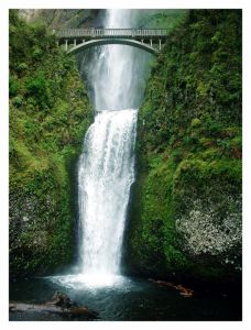 head up the hill to the view point to take in the magnificent river that serves as a border and divides the states of Oregon and Washington. Whether you take the opportunity to see Crown Point, or pass, it can be seen from the highway as well.
From I-84, exit onto the historic scenic highway 30 east. Follow the road through lush forest along side of the river, passing over beautiful moss covered bridges on the way. Soon you will arrive at the beginning of a string of waterfalls, including the famous Multnomah Falls, the most visited and photographed waterfall in Oregon. Take time to get out of the car at each stop, it's well worth the view from the bottom - of the waterfall that is! There are several hikes, the most noteworthy is up to the beautiful concrete bridge that sets halfway up Multnomah falls with just a 1/4 mile hike up a well maintained paved trail. For the more adventerous tourist, you can make the remaining trip up to the top of Multnomah falls in about 20 minutes. For the return trip, continue east on highway 30 towards the Dalles, reconnecting with the I-84 west towards Portland.
For an extended day trip (round trip approximately 120 miles), you can continue on the I-84 east towards the Dalles, stopping in Hood River to enjoy lunch overlooking the Columbia River. Hood River is considered to be the windsurfing capital of the world, and is nestled in the hillside along the gorge. Once through Hood River, take highway 35 south through the orchards, vineyards, and farmland surrounding the northeast side of Mt. Hood. You would now be on the drier side of the Cascade mountain range, and possibly get to see a great view of the mountain on your travels. Connect with highway 26 heading west, where you will pass through Government Camp - where you can enjoy the splendor and beauty of historic Timberline Lodge on the base of Mt. Hood. Continuing on highway 26 will take you along the old Barlow Trail route, a portion of the Oregon Trail. You will pass through the Villages at Mt. Hood, which includes the small villages of Rhododendron, Zig Zag, Welches, and several other tiny communities, which would pretty much put you in my stomping grounds! Highway 26 will lead directly through Sandy to Gresham, where you can follow signs back to the I-84 to Portland.
Technorati tags:
entertainment, fun, hiking, life, oregon, places, travel, travel and places


On a rainy day, the Columbia Gorge Interpretive Center museum would also be a good destination.
ReplyDeleteAbsolutely right Tom, it's a great place to go! It's on the Washington side of the Columbia river, in Stevens, WA. For more information on their museum, here's their website...
ReplyDelete